Discover rewarding casino experiences. 
|
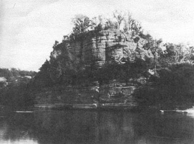
Early in the twentieth century places in the state of Illinois that had historical, cultural or a plethora of natural flora or fauna were being reserved and preserved for the future to enjoy (us). Starved Rock’s place in our history is unusual, interesting and vital in importance. It isn’t just an impassive lump of sandstone next to the Illinois River. It had living and breathing, dramatic stories surrounding it. And, after all, it is over 400 million years old. Cycles and cycles of highs and lows of ice and inland seas once covered the countryside. Glaciers and rock pressed down on silt and sand to make unbelievable rock formations here in the Northwest corner of Illinois. As they receded, much of the landscape was left with fertile prairie soil (Hurrah!) a scenery just a bit different than the flat of the landscapes to the south. Not until a little over three hundred years ago did “white men,” Europeans, make their way to the “Rock,” as the French simply called it, that in 1673 with the arrival of Louis Jolliet and Jacques Marquette, the former, not yet thirty, trained in music and as a religion but who with multiple talents, left that study to become a very capable map maker. Father Marquette, a few years over thirty, was a Jesuit missionary, a gentle, sensitive soul who often suffered with several illnesses. They, with five engages in two birch bark canoes set off from Quebec to cross the Great Lakes to the mission at Green Bay, portage to the Wisconsin River and then enter the Mississippi in June of 1673. Its strong current carried them for about three days until they saw for the first time the rugged hills of northwest Illinois country. It was the first time there were words recorded about our corner of the world. They journeyed southward, writing and drawing, discussing the wonders of what they saw. They were searching for the western route to the Orient. They finally arrived at the mouth of the Arkansas River where natives told them they were close to the Gulf of Mexico and thus the end of the Mississippi. Bitterly disappointed, they decided to turn back, trying another route to Canada. The size of the Illinois River encouraged them so they paddled northeastward until discovering the impressive bluff, the Rock, where they paused because there was quite a large Indian village on the banks opposite, some seventy-four ‘cabins’ mostly Kaskaskian Indians. They explored the area and Fr. Marquette vowed to return to establish a mission there. They must leave so again paddling northward, they portaged small streams and marshes until they reached a tiny, smelly trading post later called Chicago. On to Green Bay’s head, the DePere mission where steadily hemorraging, Father Marquette declared he’d stay there for the winter (living in a small hut). Having trapped and hunted pelts to pay the large amounts of money he’d borrowed to make the expedition, Jolliet would travel on toward Montreal. Two young boys accompanied him in the canoes filled with hundreds of peltry, maps, charts, journals and “souvirs” of the trip. On the last leg of the journey, instead of portaging around some seething, flood-swollen rapids, the party attempted to ride the boats over and were engulfed by the terrible current. The two boys were drowned and all contents of the canoes were lost. A couple of fishermen discovered Jolliet near death on some nearby rocks. Payment for his debts was gone. There were other setbacks but because of his many abilities, Jolliet (spelled with two “L’s”) eventually made his way. He had at first, however, had the comfort in thinking other issues of his laboriously rendered maps and charts were safe at DePere, Green Bay mission but for some fateful reason the place had burned, the historical records with it. Nothing remained except in the memory of the explorers. Not until 1880 was anything found of maps of that first journey by white men to the Illinois country and that was not genuine. Again in 1955 an item was discovered which, though controversy surrounded it, was thought to be of Jolliet’s making because it was spelled with two “L’s”, not one as most wrote it. Because of his pleaant personality and abilities, Jolliet won grants and commissions and was able to make a living as a Hydrographer and map maker. Just as the seventeenth century was turning to the eighteenth, Jolliet and his family were traveling to their summer home and completely vanished, never to be seen or heard from again. A strange end to an adventuresome life. Meanwhile, Fr. Marquette who had remained at Green Bay the winter of 1674 was anxious to return to the Rock to establish a mission. He was always sickly but so determined, he pressed forward because the settlement was of good size and a good beginning for his religious work. Several diverse native cultures had lived in that area since probably 800-900 B.C., Archaic tribes such as the Hopewell, Woodland and Mississippian. From about 1500 to 1700 Illiniwek also settled there. Legend would arise after the Jolliet-Marquette arrival in the mid-1700’s. A series of battles took place between a combination of Ottawas and Potawatamies against the Illiniwek because they had murdered the Potawatamie leader, Chief Pontiac. Revenge was a primary mover. In the course of one campaign the Illiniwek were driven atop the Rock and surrounded by the enemy could not escape. They starved to death eventually. Thus the legend and name evolved, Starved Rock. It was interesting to learn that the legend was born as late as the mid-1700’s and not in the dim, dark past. It was firmed up by records of the European frontiersmen. A second wave of “white” explorers came about a decade after Jolliet and Marquette, Robert LaSalle and his lieutenant, Henri de Tonti, the usual military force that followed the explorers. LaSalle claimed the region for the French monarch and set about building a fort on the quarter acre summit of the Rock, a blockhouse, storehouse and dwelling. Three sides of the Rock were inaccessible from the river and ground 125’ below. A somewhat gentle plateau sloped to the Rock on the fourth side down which two small cannon were aimed to repel the enemy. The forest was named Ft. St. Louis, the second such in the river valleys of the Illinois country. Robert LaSalle was an especially able military man; intelligent, educated, daring and passionate in claiming new lands for France but for some reason, noted in more than one source, he was not likeable. There was constant mention of his squad of troops constantly giving him trouble, mutinying, squabbling and so forth. One wonders if he was too “high above” the others! He did accomplish much in the development of the Illinois country, however and his adventures are well worth reading. He made four expeditions to the Gulf of Mexico and somewhat beyond. The first was in 1682 when it was said he claimed in a loud voice(!) possession for the king of France all the region watered by the Mississippi from the Appalachians to the Rockies. Naming it for the king, Louisiana, he envisioned “an ice-free port from which without interference from Canadian rivals he could be governor and exploiter of a great French colony and conqueror of northern Mexico at the head of an Indian army.” And, as you see, he was ambitious, too. But he got things done. He made two trips back to France seeking sponsorship of additional expeditions and following one on return to North America, he brought with him the material, riggings, anchors to build the first sailing ship, Griffon, to sail on the rivers and Great Lakes, quite a feat-filled with pelts and trade goods, however, it sank in a terrible storm with loss of all aboard. On the fourth expedition to the mouth of the Mississippi and the Gulf region, LaSalle was murdered by his own men. He was left heartlessly unburied on the beach where he wa killed.
It was pointed out many times that his troops manifested their dislike of him. Only his lieutenant, Tonti, remained loyal. He undertook some of his objectives and was a capable replacement. As you see the stories surrounding the Rock are filled with adventure, drama, the romance of the daring, colorful and are just a small chapter in the history of Illinois. Excitement today is clasing gears. Read about the past and why we should be observing the birthday of just one of our state parks. Next week—a little bit more. |